

What to expect when building on rocky land in Texas
Most Hill Country land is a few inches of soil over layered limestone. Here is how that rock shapes roads, pads, trenches and septic, and how crushing puts it to work.
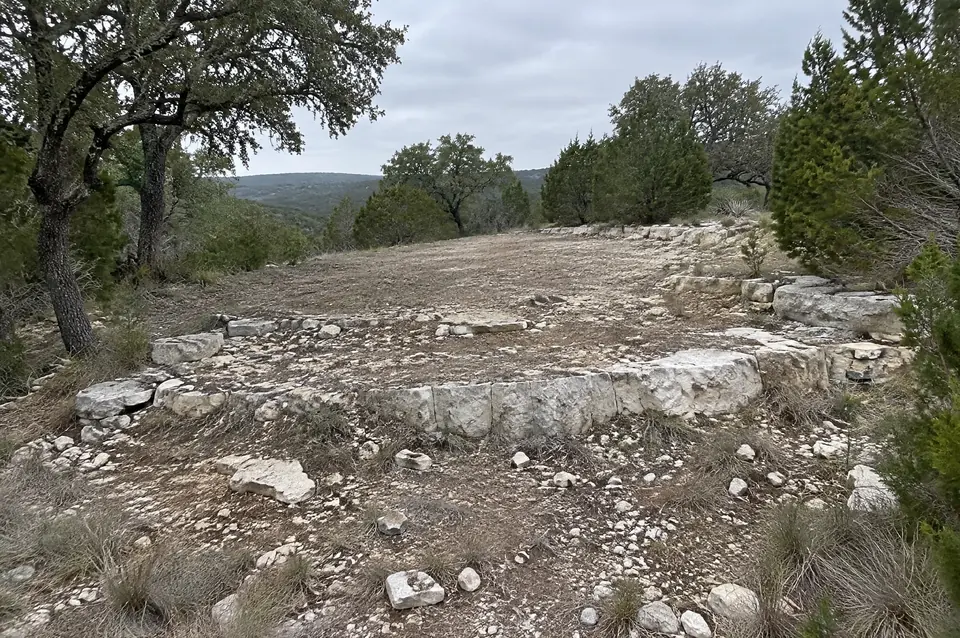
What should you know before building on rocky land in Texas?
Building on rocky land in Texas usually means working in rock, not soil. USDA soil descriptions put limestone bedrock 4 to 20 inches down across most Hill Country uplands, so roads, house pads, trenches and septic systems all reach ledge. Plan for rock tools, check aquifer rules, and use on-site crushing to turn that rock into road base.
Building on rocky land in Texas usually means building in rock, not dirt. Across most of the Hill Country, a few inches of stony clay sit on layered limestone, so every road, house pad, trench and septic system reaches ledge before the job is done. That same rock can become your road base, and on-site rock crushing in Central Texas is how we turn the problem into the material.
Our family crew is based in Spring Branch, so this rock is home ground for us, from land clearing across Comal County to roads and pads. Here is why Hill Country land is so rocky, how deep the soil really runs, what the rock changes in a build, and how to put it to work.
Why is Hill Country land so rocky?
Hill Country land is rocky because it sits on layered limestone that formed in a shallow sea, with only a thin skin of soil on top. Around Spring Branch, Bulverde and Canyon Lake, most of that rock is the Glen Rose Limestone. The National Park Service Geodiversity Atlas dates the Glen Rose to "between about 113 and 108 million years ago" and describes the Texas Hill Country as "characterized by shallow soils."
The Glen Rose is not one uniform rock. Hard limestone beds alternate with soft marl and clayey limestone. The hard beds hold up as ledges and the soft beds wear back, which gives Hill Country slopes their staircase look. U.S. Geological Survey mapping of the Anhalt, Fischer and Spring Branch quadrangles puts the lower Glen Rose at 225 to 240 feet thick and describes one interval with "well developed stair-step topography" (USGS SIM 3333, 2015).
Harder rock caps some hills. In that same USGS study area, a remnant of the Edwards Group about 60 feet thick caps two hills. In the Balcones fault zone of northern Bexar and Comal counties, the full Edwards Group is present, and USGS describes parts of the Edwards as hard, dense limestone and says chert occurs "as beds and as nodules throughout the Edwards Group" above its lowest 20 feet (USGS SIM 3366, 2016). Faults and fractures run northeast to southwest across the region, so Hill Country rock quality can change within a single property.
How deep is the soil over rock in the Hill Country?
The soil over rock in the Hill Country is usually 4 to 20 inches deep on the uplands. Official USDA soil series descriptions for the region's common upland soils put bedrock within about 20 inches, and only the valley soils run deep.
| Soil series | Depth to rock | What sits underneath |
|---|---|---|
| Eckrant | 4 to 20 in (typically 12) | Fractured hard limestone with chert, marl or chalk |
| Brackett | 5 to 20 in | Weakly cemented, fractured limestone, mainly Glen Rose |
| Real | 8 to 19 in | Weakly cemented limestone |
| Comfort | 10 to 20 in | Hard dolomitic limestone |
| Doss | 11 to 20 in | Soft marly limestone |
| Rumple | 20 to 40 in | Hard limestone; subsoil up to 65% chert fragments |
| Krum (valleys) | 40 to 80+ in | No rock; clay that cracks when dry |
The Comfort series alone covers more than 100,000 acres and is "mostly used for rangeland and rural homesites," which is exactly the ground people buy to build on. County records show the same pattern. One Comal County septic permit logged 12 inches of clay loam over limestone, and the designer chose aerobic treatment with drip disposal "because of unsuitable soil conditions" (Comal County Engineer's Office, permit 119088). Depth to rock also changes across one tract, so a single test hole does not speak for the whole property.
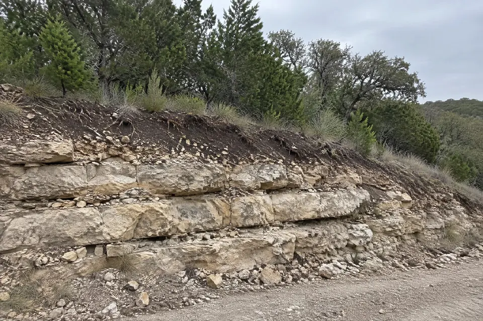
What does rock change when building on rocky land in Texas?
Rock changes the tools, the schedule and sometimes the design of almost every part of a Hill Country build. Anything that goes below the top foot of ground, such as a footing, a tank hole, a utility trench, a pond cut or a road cut, turns into rock work.
- Septic systems. Texas rules require "two feet of suitable soil" between the bottom of a standard absorptive drainfield and a restrictive horizon such as rock (30 TAC §285.33). With about a foot of soil over limestone, many lots end up with aerobic treatment and drip or spray fields instead.
- Trenches and tank holes. Fractured, layered rock can often be ripped with a dozer, while massive rock with no planes of weakness resists ripping. Federal Lands Highway rippability guidance, drawn from Caterpillar's handbook, notes that "rock that is too hard to be ripped is fragmented with explosives" (FHWA CFLHD manual). Rock saws such as the HydraWheel line cut trenches 9 to 46 inches deep "through rock, concrete, and other tough materials" (Ditch Witch, 2022).
- House and barn pads. A pad can land half on hard ledge and half on soft marl, and those layers carry load differently. Have your engineer look at any foundation pad that crosses both.
- Equipment wear. Chert, common in Edwards rock and Rumple soils, is microcrystalline quartz rated "7 on the Mohs Scale" (Geology.com, Chert). A steel file rates 5 to 6.5 and the calcite in limestone rates 3 (Geology.com, Mohs scale), so chert wears teeth, bucket edges and crusher hammers fast.
Our site work and utility installation crews work in rocky terrain and difficult soil, cutting pads and excavating for septic systems, propane tanks and utility trenches up to about 4 feet deep.
What happens if digging opens a cave or sinkhole?
If digging opens a cave or sinkhole, work near the opening should stop until someone qualified looks at it, and on the Edwards Aquifer recharge zone stopping is the law. Hill Country limestone dissolves over time. The Edwards Aquifer Authority explains that rainwater picks up carbon dioxide, flows through fractures and pores, and slowly dissolves the limestone "to form conduits and caves."
Caves are part of this landscape. Honey Creek Cave, inside the USGS study area that includes Spring Branch, is "the longest explored cave system in Texas at over 20 mi" (USGS SIM 3333).
On the recharge zone, Texas rules say that if a sensitive feature turns up during regulated work, "all regulated activities near the sensitive feature must be suspended immediately," and the TCEQ regional office must be notified (30 TAC §213.5). The Edwards Aquifer rules cover parts of eight counties: Kinney, Uvalde, Medina, Bexar, Comal, Hays, Travis and Williamson (30 TAC §213.21). Kendall, Kerr and Blanco are not on that list. Check your parcel on the TCEQ Edwards Aquifer map viewer.
Off the regulated zones, a machine can still break into a void. Treat a sudden drop, a hollow sound or ground that swallows water as a reason to stop and assess.
How does on-site rock crushing turn rock into building material?
On-site rock crushing turns rock into building material by breaking the stone where it lies into a fine, compactible road base, with no imported base to buy and haul. Federal guidance backs the idea: the FHWA Gravel Roads Construction and Maintenance Guide (2015) says broken stone embeds into a gravel road surface much better than rounded, natural stone.
Depth matters on thin soil. Skid-steer crushing attachments are rated to work about 4 to 6 inches deep (Compact Equipment, 2026; FAE STC/SSL), which mostly reworks soil and loose surface stone. The deep tractor-driven heads are rated to about 35 to 50 cm, roughly 14 to 20 inches (Seppi MAXISOIL; FAE RSH/HP), deep enough to reach ledge. Those are manufacturer maximums. 9 Arrow runs a large, dedicated rock crushing machine built to work far deeper than the skid-steer attachments most crews use. As far as we know, no other crew in the Hill Country runs one. Our post on why rock crushing depth matters explains what that depth reaches.
Crushing and road building disturb soil, which puts them in a different category from forestry mulching. Edwards Aquifer rules exclude "clearing of vegetation without soil disturbance" (30 TAC §213.3), but on the recharge zone, roads and excavation need an approved plan before work starts, at any size (TCEQ). On the contributing zone, the trigger is 5 or more acres. Disturbing an acre or more anywhere in Texas brings in the TCEQ construction stormwater permit (TXR150000), and mechanized digging 16 inches or deeper counts as excavation under the Texas811 law (Tex. Util. Code §251.002). Confirm your project with each agency; this is a summary, not legal advice.
Start with a walk over your ground
The right plan for rocky land starts with a site visit: where the ledge sits, where the road and pad need to go, and what the rock can become. See how our on-site rock crushing service turns Hill Country ledge into road base, and compare it with trucking base in on our crushing vs hauling road base page.
Sources
- Geodiversity Atlas, Lyndon B. Johnson National Historical Park, National Park Service
- Geologic framework of the Anhalt, Fischer and Spring Branch quadrangles (SIM 3333, Clark and Morris, 2015), U.S. Geological Survey
- Geologic framework and hydrostratigraphy of the Edwards and Trinity aquifers, northern Bexar and Comal counties (SIM 3366, 2016), U.S. Geological Survey
- Official Soil Series Descriptions, USDA Natural Resources Conservation Service: Eckrant, Brackett, Real, Comfort, Doss, Rumple, Krum
- On-site sewage facility permit 119088, Comal County Engineer's Office
- 30 TAC §285.33, Criteria for effluent disposal systems, Cornell Legal Information Institute
- Determining the rippability of rocks, FHWA Central Federal Lands Highway Division manual (City of Lawrence archive)
- Ditch Witch acquires HydraWheel line of rock saws (2022), Ditch Witch
- Geology.com: Chert, Mohs hardness scale
- History of the aquifer, Edwards Aquifer Authority
- Edwards Aquifer rules, 30 TAC Chapter 213, Cornell Legal Information Institute: §213.3, §213.5, §213.21
- Edwards Aquifer map viewer, Texas Commission on Environmental Quality
- Water Pollution Abatement Plan, Texas Commission on Environmental Quality
- Stormwater permits for construction sites (TXR150000), Texas Commission on Environmental Quality
- Texas Utilities Code §251.002, Definitions, Texas Public Law
- Gravel Roads Construction and Maintenance Guide (2015), Federal Highway Administration
- Stone crushers lend a hand in site prep, land clearing and more, Compact Equipment (2026)
- STC/SSL stone crushers for skid steers data sheet, FAE Group
- Seppi MAXISOIL specifications, International Mowers
- RSH/HP stone crusher specifications, FAE Group